Oregon-California
Road Trip (July 2016)
Sally and I took a
road trip to Oregon and California. The main goal was to see our daughter
Alice who was working in Palo Alto for the summer. We started on July 1 with
a car packed with camping gears. In the first portion of the trip, we have
only two planned destinations: stay with our old friends from graduate
school, Mike and Juanita, in Portland, and tickets to a play (Richard II)
in the Oregon Shakespeare Festival on July 5 and a hotel reservation there
the night before.
We wandered all over the place, on and off the grid, camping
and hiking, and checked into hotels once a while for R&S (showers).
Oregon
We started around noon from Bellevue and quickly encountered
traffic - not surprising. Thanks to Google Maps, we wandered along the
backroads south of Tacoma which saved us from sitting on the freeways. But it still took us more than 4
hours to reach Portland. While Mike and Juanita complained about the traffic
in Portland, it is nothing compared with our area.
After a nice visit with them, we headed off to the Willamette
National Forest area. Very quickly we found out it was very crowded and all
the campsites are full (it was July 4th weekend). We changed our
"plan" and wound up in a primitive campsite at the edge of Mt
Washington Wilderness area near the Sisters. It is next to a lake/pond with
the Pacific Crest Trail (PCT) nearby, and very few people. At night, we
have the Milky Way and frogs serenading us. However the mosquitos ate us
alive, even with Deet.
 
Wilderness campsite next to lake.
Pacific Creset Trail over lava field.
We hiked the PCT nearby. (The Pacific Crest Trail’s
well-known to regular hikers. It was made famous to the general public by
the movie "Wild".)
This portion of PCT is unusual. It meandered through a lava field
with snowcapped mountains around it. Later on we found out the lava field
was formed 1500- 2000 years ago from volcanic activities in the
region. But you can’t
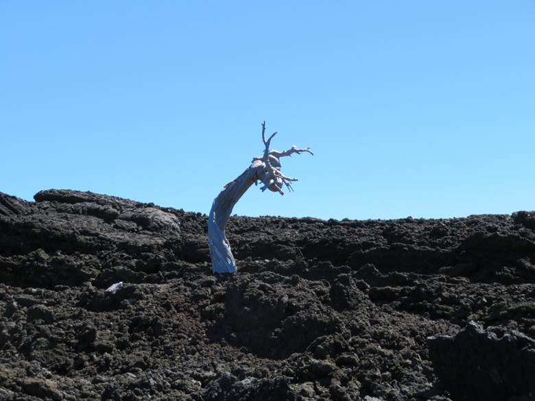
tell since the lava is still very rugged and sharp. There is very little vegetation in
the lava field. Dead tree
trunks (2000 years old?) scattered all over.
Mt Washington in the background. Dragon
rising from lava.
 
Vegetation
growing in lava.
1500
years old (?) dead tree.
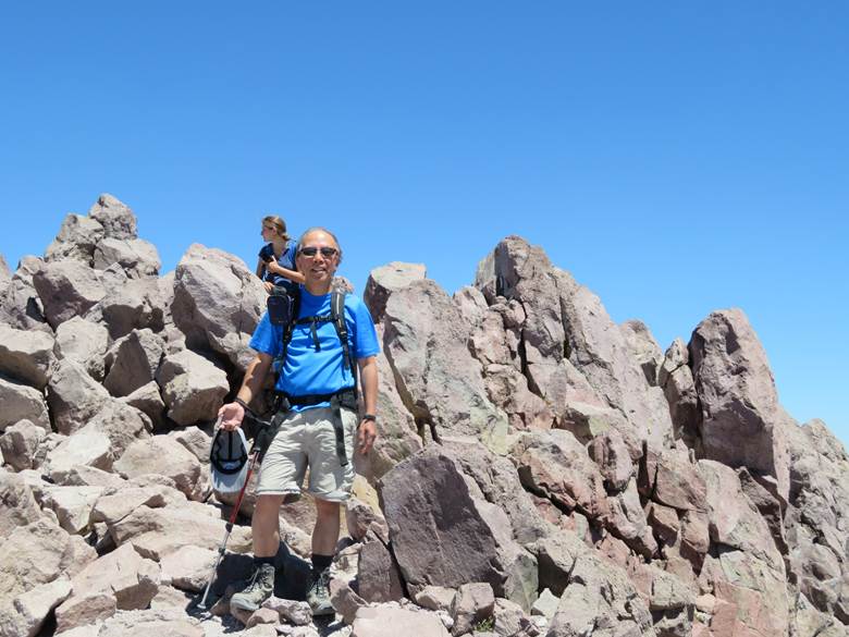
Thanks to the OSM (OpenStreet Map
offline app) and GPS signals, they allow us to venture off trail with
confidence. We went off the PCT and followed a well-established trail, but not
marked (not even in OSM), to the top of Belknap Crater. On the way to the
top, we went up steep slopes with loose ash. It felt like we were hiking a
mini Mt. St Helens. It was one of our best hikes - open country with peaks
all around, nice temperature and NO mosquitos! Belknap Crater erupted 1500 years
ago. It is amazing that the ash
is still here after 1500 years.
 
The Sisters in the background.
Loose ash trail to Belknap Crater.

Belknap Crater from Google Earth.
Next day, we decided to go to Crater Lake.
We had no campsite reservation and, since it was the July 4th
weekend, everything was full in the park. We decided to go hiking first
before dealing with accommodation. So we hiked up the Garfield Peak next to
the Rim Village. The Village was a zoo - full of people and cars. But once
on the trail, it becomes nice and quiet. The view is amazing on the trial
and up at the top. There were some snow but it was not dangerous. We even
glissaded down a snow field - fun!
 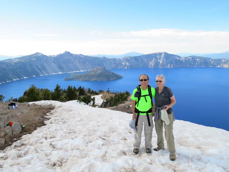
Wizard Island in Crater Lake. On top of Garfield Peak.
 
Phantom Ship in Crater Lake. Sally glissading
down snowfield.
Afterwards, we drove out of the park and headed for Fort
Klamath (a small village) with motels for R&R (more like showers). We found
two motels, one of which was all locked up - it seemed that the owners are
more interested in taking July 4th off than business. Luckily the other one
was opened with rooms available.
However, there were no restaurant in the town, or no restaurant opened
in the July 4th evening.
But we were prepared. We
took out our new Coleman stove (the 20+ year old one broke a couple of days
ago during the trip) and cooked a freeze-dried meal in front of the motel
room.
Our nice motel manager/owner told us about a firework in a
field close by. We watched a
wonderful July 4th firework courtesy of local farmers. It was a 20-minutes
nonstop show - as good as the one in Bellevue, if not better.

Sunset from motel in Fort Klamath.
In the past, we drove by signs to Klamath Falls many times
traveling along I5. This time we
decided to pay it a visit since it is right there near Fort Klamath. The obvious question to ask is where
are the falls, or are there falls? We found the answer in the Klamath
Falls Museum. The falls are
located at the edge of the town.
They said the falls used to be much higher, but due to damming,
etc., it is more like a rapid now.
You have to walk about a mile on a dirt road along a river to find
it. That area is great for
birding. We even saw our first
pelicans in fresh water. (After
living in California for 9 years, we always associated pelicans to salt/sea
water, after seeing them zoom around along the beaches).
 
Klamath Falls in the town of Klamath
Falls.
Freshwater
pelican.
The Oregon Shakespeare Festival play (Richard II) was good. We
sat near the front with a great view of the stage. We can actually hear the
spoken words very well although understanding them is a different matter.
We were amazed by how easy the traffic was in Ashland. No wonder a lot of
people retired there.
California
From Ashland, we turned westward heading to the Californian
coast. The main attraction is
Crescent City (of tsunami fame) and the Redwood State and National
Park. We managed to find a hike
down to the coast.
 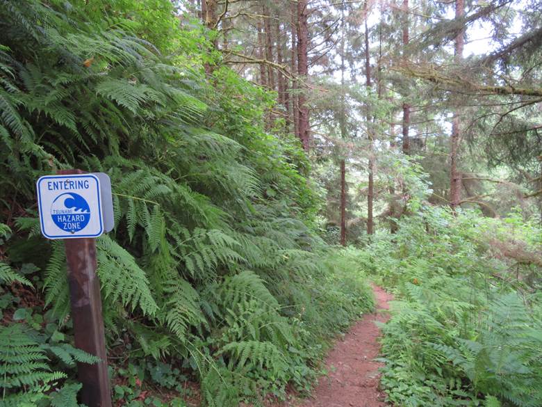
Sea lions in Cresent City. Tsunami warning sign on trail.
The Redwood Park is a sprawling stretch of preserved old
growth redwood forest. It is
hard to distinguish the National Park from the State Park. There is no much information on the availability
and even the exact location of the campgrounds. After driving along the deserted
Avenue of the Giants (a highway within the park with giant Sequoias), we
ran into a park ranger who told us about a horse camp nearby. So we had our first camping
experience with the horse.
It was much better than we anticipated. There was a lot of space in each
campsite – for the horse and trailers. So our little tent fitted in there
nicely. There was not much
smell – the horse owners cleaned the horse manure every morning.
 
Sea stacks near Crescent City. Horse camp.
 
Among the giants.
After having coffee with a Bellevue friend’s daughter in
Ukiah, we headed for the bay area.
Bad timing! We crossed
the Golden Gate Bridge around 5pm, in heavy traffic, of course. Google directed us into SF city
streets in stop-and-go traffic.
Presumably the freeways were all jammed up. Eventually we arrived in Palo Alto
to meet our daughter for dinner.
So we spend the next few days enjoying the “good
life” in the bay area.
This includes seeing the $1500 per month room in boarding house that
Alice lives in (luckily the company that she interned in the summer paid
for it), driving from freeway to freeway visiting friends and relatives,
nice and hot weather, and good (and expense) food. One surprise we found was the green
belts in the SF Peninsula.
Somebody had the foresight and vision to preserve these open areas
way back for recreation use.
Finally we said goodbye to Alice and headed home. But we stopped in Lassen Volcanic
National Park first. We visited this park before with young kids but
couldn’t do much hiking.
We vowed to come back someday and here we are.
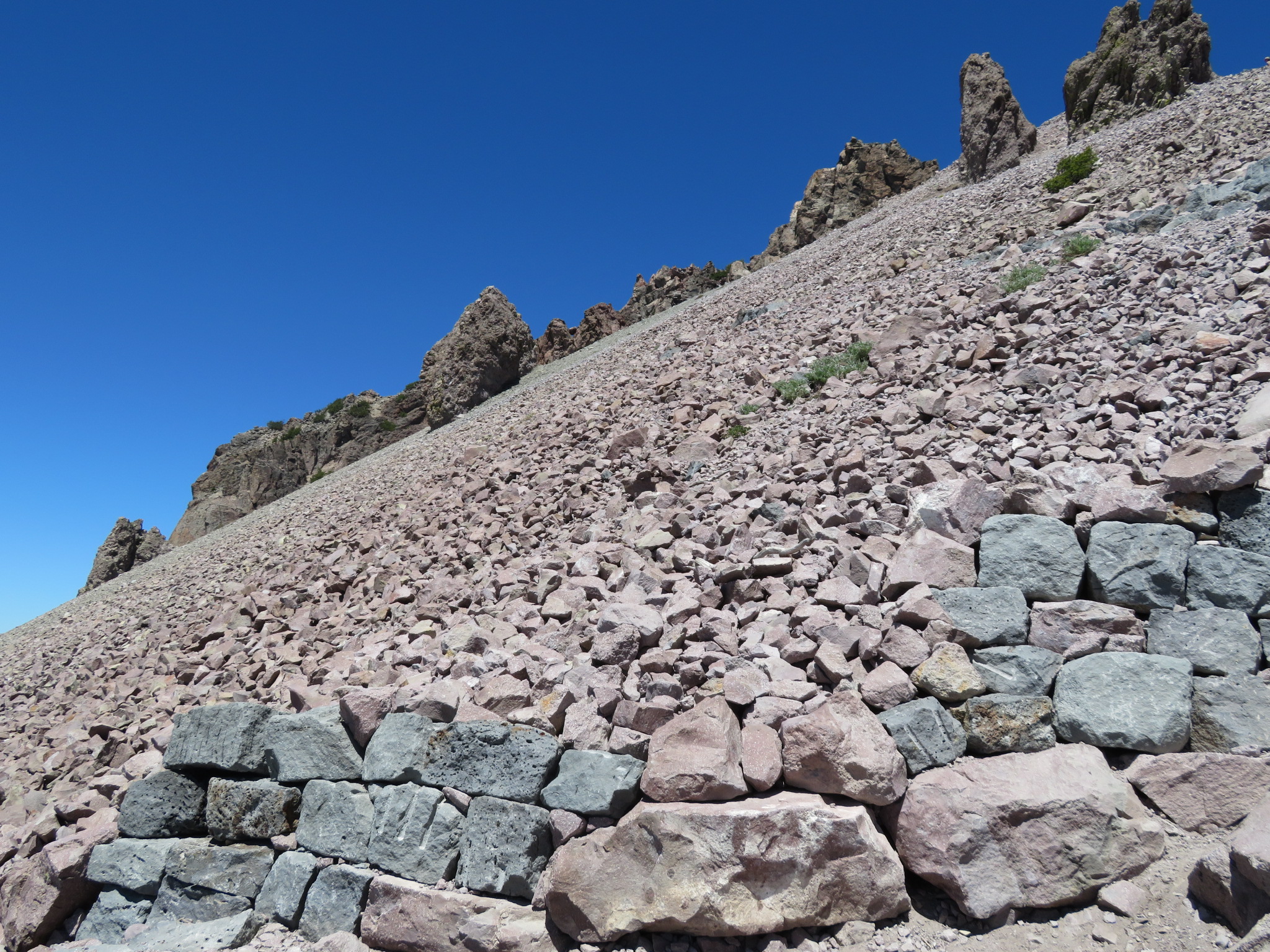
Lassen is relative unknown because most of the park is a
designated wilderness area although there are two campgrounds that one can
drive to. It is like a mini Yellowstone Park with hypothermal vents,
bubbling mud and sulphur deposits. If you want to bag a volcanic peak,
this is a good one. You start at 8500 ft and the
peak is at 10460 ft, an elevation gain of 2000 ft in 2.5 miles.
It was mid-July but there was still plenty of snow. Some lakes
are still semi-frozen and some trails were still close. We have to cross snow fields several
times on the Lassen Peak Trail.
It was not too bad because past hikers have already tamped down the
snow. But it was not for the
faint of heart either.
On the way up I noticed a guy hiking on the other side of the
ridge away from the designated trail.
I thought that he was one of those that like to wander off (although
this kind of behavior was discouraged). Then we saw him again further up but
he was still on the other side of the ridge. His movements were somewhat hesitant,
unlike someone that wandered off on purpose. We called out to him and found out
that he was lost. We directed
him towards us, across a steep snowfield and border field. He was very grateful of our help.
Apparently he missed the small flags in the snowfield further down and
wound up in the wrong place.
He was doing one of his bucket list summit trails; trails of
2-3000 ft elevation gain and 5-7 miles round
trip. Interestingly Mt Si is on
his list.
So we bagged the third volcanic peak for this trip.
Frozen lake at the Lassen Peak trailhead. Off Lassen Peak Trail.
 
Lassen Peak.
Final
ascent to the summit along the ridge.
 
Crater before the summit.
At
the summit – Mt Shasta in the distance.
Looking up at the summit from the crater. At the summit.
Mt Shasta is north of Mt Lassen. We didn’t plan to hike
Shasta. But we were early on
our way home and so we stopped at the village of Mt Shasta which is just
off I-5. A nice lady at the
visitor’s center told us a perfect place to see the “Shasta
glow” (the equivalent of alpenglow). So we went to this park next to
a lake and waited for the sunset.
When we arrived at the park, it was deserted except for three
women and a dog. This dog went
straight at us, barking like crazy.
The three women were huddled together, looking at something. They ignored the behavior of their
dog until we complained to them.
We joked, between ourselves, that they were witches. (Mt Shasta is
known for its spiritual energy for mystics, gurus, and sages).
Anyway we waited for the sunset and saw our Shasta glow. Apparently the three women
weren’t watching the glow since they slipped away without we noticing
(we sat facing the mountain with our back towards them).
We didn’t think much of it until the next morning. We planned to go hiking in Mt Shasta
that day. But Sally woke up
with a splitting headache and nausea.
We decided to drive straight home from there. We wondered if we cursed by the
“witches”!
 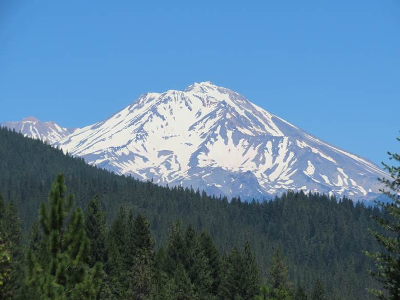
Mt Shasta from the freeway. Mt Shasta.

Shasta Glow
Sign Guestbook
Back to Home Page
|