
Kepler TrackThe "Fellowship of the Boat" journey started on February 20. Judy dropped us at Sydney airport and continued on to work (she joined us later after our hike). The 2-hour flight took us to Queenstown in the South Island near the Fjordland National Park. We noticed the green mountain ridges with very stark timberline – timber below, open meadow above, and some landslides (gray gravel patches). We later on found out that there were lots of clear cutting of forests when the Europeans were settling in the country – for the timber and clearing for sheep grazing.  We were joined by KK and Helen (who live in Hong Kong and sometimes live on a boat in New Zealand), and Wing and Magdalen (who came from the US - San Francisco to Auckland to Queenstown – a total of 24 hours flying and airport waiting time) at the airport. We drove for 4 hours to Te Anau and stayed overnight in a big rental house. Next morning Elisha, Wing, Sally and I embarked on the 4-day hut-to-hut trek on the Kepler Track while others went to sightseeing. 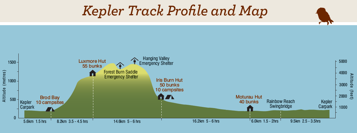

The Kepler Trek is about 60 km long and will take us four days, staying overnight at 3 huts. The total elevation gain is about 4000 ft. The highest point is on a side trail to Mount Luxmore, 1472 m or ~5300 ft. There are 3 huts on the track, separated by 15 km and 6 hours of hiking. Each of the 3 huts is equipped with bunk beds, a communal kitchen with gas stoves, and a dining room. The hike is like a backpacking trip but you don't have to carry the tents and camping stove. You still have to carry your sleeping bag and 4 days of food. There is drinking water (from taps) in the huts. In case you are wondering, there is no shower, but there are sinks and flush toilets, and a "wash room" in which you can clean your body in private. In addition to the huts, there are several emergency shelters along the track, with minimal facilities. Day 1 Tuesday Feb. 21st The first day of our trek ended at Hut 1 (Luxmore Hut). The first part of the track is very level and long through the forest with red beech mostly at this elevation. Then it is all uphill with a 3000 ft elevation gain. At upper elevations, there are more mountain beech and silver beech. A tree with pale tan peeling bark is called fuschia. As we started into the forest, we met three silver-haired gentlemen in their 70s who were volunteers setting stoat traps. They explained that stoats, rats, and mice and weasels (all introduced) eat the eggs of native NZ birds and have eradicated whole populations. This trapping program is an attempt to restore the birds, particularly the kiwi, a flightless bird that lays its eggs on the ground. It was cloudy and misty early in the day. Before getting to Luxmore Hut, we were hiking above the bush line. The day became more sunny and cool, but we sweated on the ascent. Elisha and Sally did quite a bit of singing on the way up, he sang even on the steep parts where the rest of us needed to save our breath just to pant. (He and Sally know a lot of the same old 1970s pop and folk tunes.) We were told that Wing has problems with his vision (one eye nearly not functioning) and his ability to see the ups and downs of the trail ahead might be limited. We all promised to take good care of him. But Wing did not have much problem on the track. In fact, while we would have taken more rest breaks, he preferred to march on at a steady speed. At a result, we actually arrived at the Luxmore Hut ahead of the "advertised average" of 6 hours. Not bad for a bunch of 60+ young people. At the hut, we were able to find bunks together, but only upper ones were left. The communal room was large, with efficient stainless steel counters holding the sinks and gas burners on one side, and a series of wooden tables and benches on the other. Sally talked with a young woman from Australia who had emigrated with her husband from UK 12 years before. She was hiking with husband and husband’s parents (from UK). They were cooking really good stuff, with sun dried tomatoes and garlic and olive oil and veggies. Sally learned later her father in law (in mid-60s to early 70s?) was struggling with the hiking (feet? knees?) and so his pack contents had to be redistributed to the young couple. Our early evening at Luxmore was beautiful and sunny and we could see the lake and other mountains below. 


Day 2 Wednesday Feb. 22nd It started with mist and clouds at the Luxmore Hut, tramping higher and higher into wetness in the open meadow high above the timberline. This day of the trek could be the most spectacular, with views of several peaks and deep valleys between. After about 1 to 2 hours we reached a side trail to the summit of Mt. Luxmore. We left packs at bottom and hiked up to top hoping for views, accompanied by young Malaysian (ethnic Chinese) woman Trish who was hiking alone. As we loitered around the summit, the clouds would part a bit to south or to north, revealing green hillsides and valleys below, but never a full clear view. Back at the bottom of the side trail, eating lunch, 2 young Germans arrived having started that morning from a campsite near the Te Anau trailhead – so they were doing 28 km in one day. The woman was happy to sit and chat while her companion whipped up to the summit for a look. He didn’t get a clear view either. 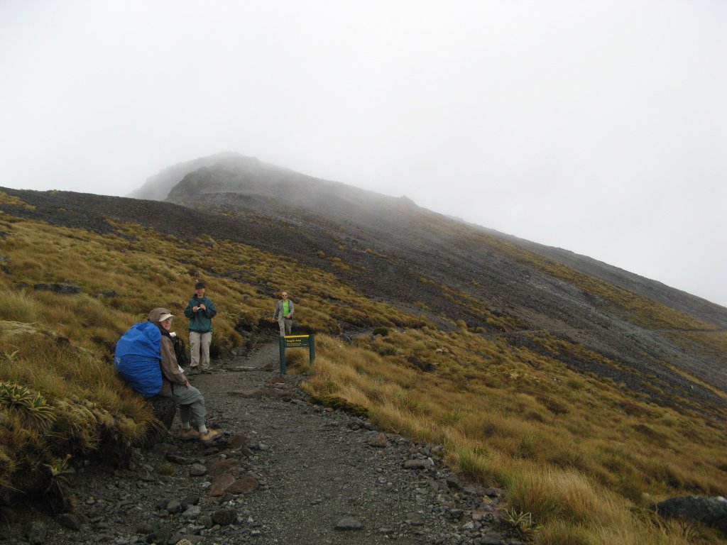


The next few km were glorious. The views opened up quite a lot more as we hiked over a series of saddles, up, down, up, down, with narrow knife edges and dramatic sweeping views below. No clear views of summits, but the views looking down from the saddles/knife edges were great. There were two shelters along the way--A-frame structures with wooden platforms and outhouse out back. At the second one, which came after all the saddles, we met two young Israeli women who were chilling out while hoping that the summit views would open up. They were very cheerful and talkative. 


We continued on and met the ranger for the 2nd hut (Iris Burn) named Robbie. He noted he was heading on up to find the two Israeli women as it was getting dark. They were headed to Iris Burn campground. He told us there were 97 switchbacks ahead of us going down to Iris Burn, or we could count the stoat traps (identified by pink numbered markers on the trees) - number 113 would mark the end.  (Google Earth)
The 97 switchbacks (we lost count) were tough on the knees. Both Wing and Sally had pain in our right knees, he worse than she. At the hut we were some of the last to arrive for the night, and only upper bunks were available, in a kind of loft where Sally was on the end under a beam (ow! If she sat up without thinking!). We made our first dried food dinner - lamb fettucini, pretty tasteless. But ranger Robbie had some great stories about treks across the Kepler with high winds, flinging 12-year old children down onto the ground, terrific rains, etc. He also said some of the hikers that day had seen a kea (NZ mountain parrot) and that the night before he had heard a kiwi in the meadow (they are generally active at night, not during day). Following instructions from Ranger Robbie, we took a night walk through the woods near the hut to see glow-worms. (The New Zealand glow worm is the larval stage of a gnat, Arachnocantha spp). One site was along the trail to the Waterfall, in a steep embankment. The other site was in a cavity in the soil behind Iris Burn where a huge rock had apparently been removed. You hopped into this grave-like hole and pointed your flashlight up at the edge at ground level, and underneath overhanging gobs of soil and grass, were these tiny hanging threads – each one a mm or less in diameter, with black and white horizontal stripes – with a “light bulb” hanging from one end or the other, apparently to lure prey or a mate? - Quite amazing. 

Day 3 Thursday Feb. 23rd A steady rain pounded the tin roof of the hut all night. (The other even more inevitable sound in the bunkroom at night is someone snoring.) The next morning Elisha made oatmeal as usual for breakfast. Someone offered us their leftover milk made from milk powder and it made the oatmeal very tasty. (The day before we had lucked out as well, with someone offering us a half carton of long-life milk.) We waited as long as we could but the rain did not stop. So we headed out in steady rain. Although there was some continuing down-hill hiking, for the most part day 3 was pretty level, but Wing’s right knee continued to hurt. He and Sally both took Motrin earlier. Within an hour we came to an open meadow with a few tall trees. A flock of small swallow-like birds, nondescript light brown in color, streamed through the low brush and middle height trees. Up in a tall tree we spotted two large black birds, and lower down, a third bird grooming its feathers. As we walked past we could see it clearly had the hooked beak of a predator. We think it was perhaps a black falcon, according to the NZ bird book at the 3rd hut. Seemed like kea would show their greenish feathers, which we did not see at all. The rain continued and we continued getting wetter and wetter. We all had hats and rain jackets, Elisha his umbrella, but our pants (the nylon hiking kind that zips above the knee) were not waterproof. The forest was lush, green, thick with mosses and spectacular mushrooms, much like our own Hoh Rain Forest, but with different tree species – and stoat traps every 200 meters. We had been using these traps to estimate our distance traveled. 

We found a shelter where we could shake off some of the rain and eat our peanut butter and jelly sandwiches. A young Israeli man joined us. He was hiking in the opposite direction, toward the Iris Burn (#2) Hut. He just finished graduate school and was traveling around before taking a job. We were joined by the two young Israeli women again. They told us they had gotten soaked at the Iris Burn campground (did not have reservations for the hut) – had woke to the rain and found their tent sitting in a pool and their sleeping bags soaked. They hurried out to see what they could do in the third hut; luckily they have reservations for that one. About an hour away from the last hut, Elisha and David noticed that Wing was favoring his right knee. We stopped to assess the situation. Elisha wanted to strike out for the hut to bring back a stretcher and some volunteers to carry Wing to the hut. Wing insisted on trying to make a crutch out of his two hiking poles and Elisha’s extra pole. He had an amazing array of stuff with him to work with – a roll of duct tape, plastic tie bands, rubber bands (like a true Boy Scout – he was prepared). We spent 20 minutes trying to tape a crutch together, with Elisha and David trying to get Wing to tape the poles together in a way that would be strong enough to hold his weight. But when all taped together, it was not tall enough for him to use properly – it required him to bend over on his right side with the hurting knee. It was quite a drama. Elisha kicked into his "rescuer mode". He insisted on going ahead of us for a stretcher and to alert the ranger – "We are losing valuable daylight and we have 6 more km to go!" (It was 4pm and the sun sets at 8-8:30). David insisted that we reallocate Wing’s belongings to our packs and continued to move forward. Sally was getting cold as the delay continued - we were all wet and not moving. We were happy when Elisha set off on his own (to go get help as he continued to insist), with walkie talkies distributed between Wing and Elisha. David and Sally redistributed Wing's stuff as much as possible into our backpacks. We then took turns carrying Wing’s much lightened backpack in addition to our own. 
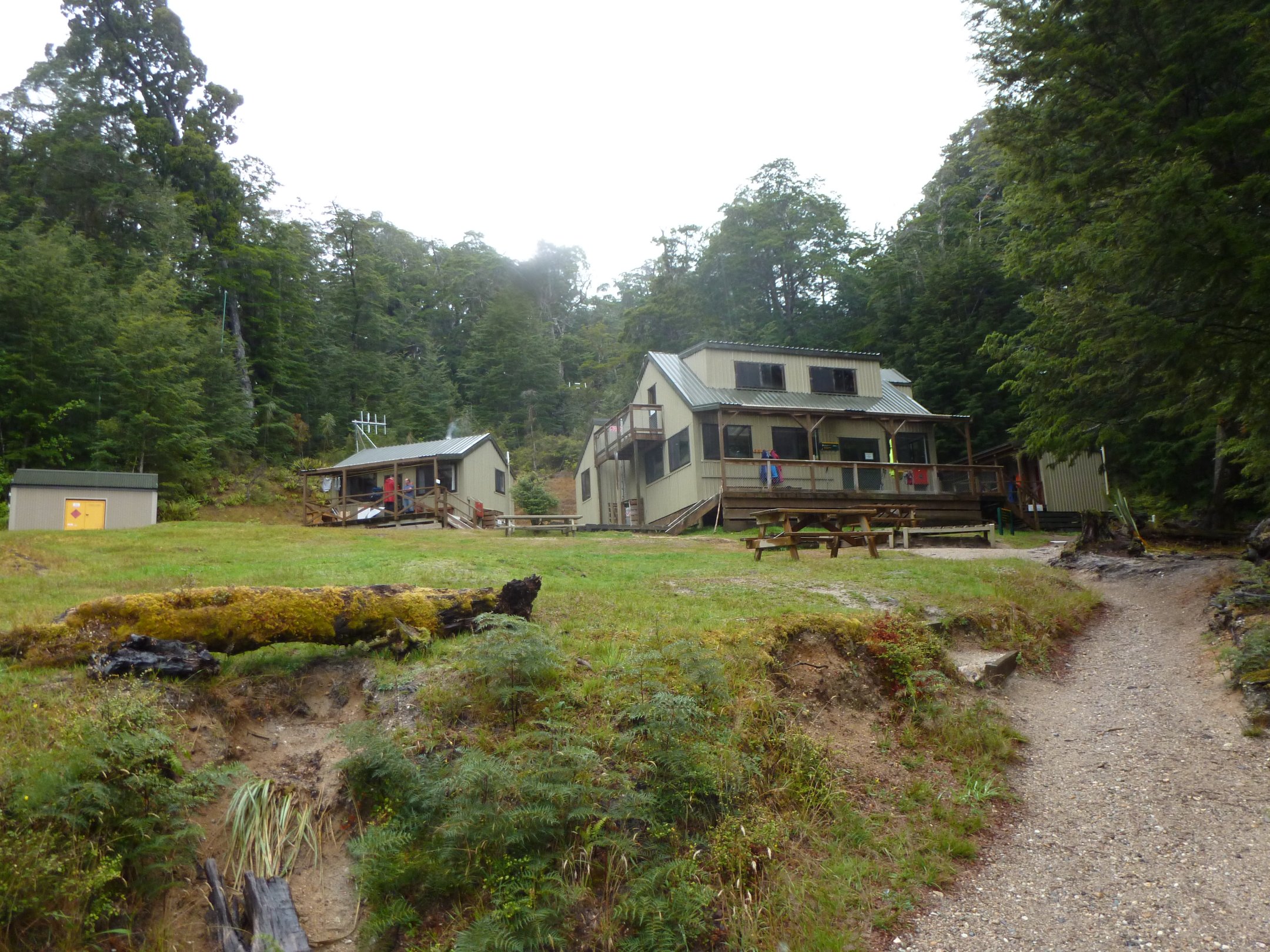
Without his pack, Wing was able to walk fairly normally, and was back to his two poles, as we had undone the duct-taped “crutch.” As we walked, we estimated that we were only 4 km from the hut, using the stoat traps. In about an hour the three of us made it to the hut. As we got closer to the hut, we started to wonder why Elisha was not back helping us. David wondered aloud if Elisha had gone all the way to Rainbow Reach for help after failing to get a stretcher at the third hut. We decided that we should stay at the third hut no matter what Elisha had done. (We joked with Elisha about this later - the reason that he had taken off was to avoid carrying Wing's stuff). We came smiling into the open – the clouds had lifted and the rain had finally stopped and were greeted by fellow trekkers who told us Elisha was under ranger orders not to try to go back to help us. The ranger (Kay) was required to report a party in trouble and had to await instructions from her bosses (Bureaucy kicked into action). (Because Wing had not actually had an injury resulting from an accident, he was not qualified for a Medevac. There was no stretcher at the hut.) At the hut, we met the two Israeli girls again. There was a wood stove burning, creating wonderful dry heat, and there were racks from the ceiling on which they (and others) had hung their wet clothing and their soaked sleeping bags. A woman had lent them dry clothes and happily their sleeping bags seemed to be getting dry. That night David and Sally had some enjoyable conversations – with Lita, one of the Israeli women; with a Danish guy and his wife in their 20s who were on their way up – into the steady downpour – he seemed ready for the challenge but she looked gloomy at the prospect – and with a woman from the North Island who gave us ideas of things to do and see on the North Island. Lita had finished her military service and shared her dilemma about choosing universities – whether to go to one which offered the conservation/ecology course of study she was interested in, or to a different one that had the course for becoming an art teacher. She asked us about our career choices, university choices, and our work at different points of our lives. She gave us her email address in case we get to Israel at some point (she has worked as a tour guide). As you might, it is not easy to sleep in a room with 20 or more people. But I had no problem falling asleep the first two nights, including the night before with the downpour pounding on the tin roof. However, tonight I could not fall asleep for quite a while. In addition to the snoring, I also heard this sound throughout the night. Later we found out they are kiwi mating calls. I guess I was lucky. Day 4 Friday Feb 24th Ranger Kay allowed us to leave, once we had filed our “plan” for getting Wing out safely. She actually gave us 4 options: (1) to carry Wing's stuff ourselves and hike out, (2) she would carry Wing's stuff and hike out with us, (3) to hire a jet boat to take us out via the lake, and (4) to have a Medevac. We took the first option – we redistributed most of his load among the three of us, and Wing just carried the rather empty pack. We walked out to Rainbow Reach just over the river, where KK had parked our car an hour before. The trek was 2-3 hours, and Wing seemed to have no problems, with us carrying his redistributed load. There were two stretches of trail with 1-ft deep swamp on either side, the trail was a solidly built wooden boardwalk with the typical chicken-wire fencing tacked down on the wooden surface for traction. At the first boardwalk, looking at the swamp, David and Sally were gesturing to one side, saying, ah, if we were in Alaska there would be a moose in our view, not noticing the other side (which Wing was noticing) where the boardwalk widened out to a viewpoint with a signboard explaining the value of bogs and wetlands: What is a bog? Continuing on into the forest, after about 10 minutes we could see a side trail heading off to the left. It was another boardwalk to a pond in a larger wetland, with viewing area and benches. Some trekkers were there as we approached and exchanged greetings, they left and we enjoyed the view in much-welcome sunshine. David and Sally considered that this might be the region of swamps in Lord of the Rings where Sam and Frodo encountered the ghosts of the dead that reached out of the wet and tried to drag them down. 

After a few minutes’ rest we returned from this side trail back to the main trail. As we reached it, a dilemma: which way did we come from? Sally thought we had come from the right, so we should continue left. The other three were sure we came from the left. Sally decided she must be wrong since she was the minority. So we set off to the right. After 10 minutes we reached the widened part of the boardwalk at the first wetland which David, Elisha and Sally all agreed we had never seen before. However, Wing said, we passed this way before – "I remember seeing the sign, What is a bog?" We overruled Wing and continued out of the wetland back into forest. After about 10 minutes suddenly a group of four trekkers appeared in front of us – we instantly recognized two of them as Lita and her trekking buddy. “What happened??!” Lita called out in consternation (to see us heading back to Hut #3!) Oops. So, laughing, but also with chagrin that we could be so easily turned around, so erroneous in our deference to the majority view, and having lost time and energy when we needed to economize on Wing’s hiking time, we reversed our direction once again. This became a trek watchword for the coming days, a reminder as we continued our travels – “You may be 100% confident but 100% wrong!” and a note about the fact that decisions based on majority opinion can be completely wrong. We came to Rainbow Reach in sunshine after crossing the Waiau River, very wide and energetic, on a wide, swaying footbridge. We got in the car at 11:20 am heading for the Luxmore rental house at Te Anau where Wing, David and Sally showered and changed. Elisha had washed up at the hut and said his clothes were clean enough. Reconnected with KK, Helen and met Deborah and Lok who had arrived late Tuesday evening in Q-town (had to return for gas at 11 pm because stupid Omega car rental had sent them off with a car with ¼ tank of gas). That is the end of our first adventure. Sign Guestbook Back to Home Page AU-NZ Home Sydney Kangaroo Island South Island Mount Doom Rotorua Hobbiton |